Macroseismic Intensity Data Online Publisher


Input data table formats
The Deliverable 4 "European Macroseismic Database" of the NERIES NA4 project called “European macroseismic database 1000-1600, M > 5.0” and its continuation in Deliverable 7 part 1 “European Macroseismic Database 1000-1750, M > 5.0” tries to establish a series of guidelines for macroseismic data compilation and validation.
MIDOP has been designed by the AHEAD Working Group and adopts all of its guidelines and it is currently used for publishing intensity maps of AHEAD (the European Archive of Historical Earthquake Data).
Field names presented in this page are merely a suggestion as MIDOP is able of associating any field contained in your table.
Please, note that there are restrinction rules within the field name, common rules while dealing with database tables:
- no spaces;
- no special characters, the only "safe" character is "_";
- no duplicated names.
The following symbols are used in this page:
-
 specifies which field should be used as the table primary key.
A "primary key" in a database table refers to a field that contain values which cannot be ever repeated within the same table and are used
in order to uniquely index the record of the table. Read the explanation about primary keys on Wikipedia. -
 specifies which field in the table should be indexed.
An indexed field greatly improves the speed of data retrieval operations.
Indexing your tables is important when you have a lot of data, making MIDOP much snappier while generating both maps and tables.
Read the explanation about database index on Wikipedia. -
“*” specifies a required field.
Please note that other fields are not necessary but MIDOP will use them when filled.
List of tables:
Earthquake catalogue table
The earthquake catalogue table contains the complete list of earthquakes that you are going to publish within MIDOP. It contains all the information about the whole earthquake, such as the origin time, the epicentral area and the source of information from which data are taken.
| Field | Description | Type |
|---|---|---|
| EQid * |
Earthquake unique identifier. Trailing spaces and special characters must be avoided (a simple integer number is advisable). (field used retrieving all the corresponding macroseismic intensity points) |
text or number |
| Year * | Time of the event (year). Note that negative values are accepted. | integer |
| Mo * | Time of the event (month). | integer |
| Da * | Time of the event (day). | integer |
| Ho * | Time of the event (hours). | integer |
| Mi * | Time of the event (minutes). | integer |
| Se * | Time of the event (seconds). | integer |
| Ct | Comment to time. | text |
| Ax | Denomination of the area where the largest effects are located. | text |
| AxShort | Denomination of the area where the largest effects are located (shortened). (field useful for html tables that have a character space constraint) |
text |
| Et |
Earthquake type. Allowed values are: earthquake, induced earthquake, quarry blast, explosion, chemical explosion, nuclear explosion, landslide, rockslide, snow avalanche, debris avalanche, mine collapse, building collapse, volcanic eruption, meteor impact, plane crash, sonic boom, not existing, other, null |
text |
| EQdeaths | People died during the earthquake. | text |
| EQinjured | The number of people injured during the earthquake. | text |
| EQlink | Link to an external webpage with more information about the earthquake. | text |
| EQnotes | Useful notes about the earthquake. | long text |
| MDPsetID * |
MDP dataset identifier. (field used to link to the corresponding list of MDPs. In our experience the identifier of an earthquake differs from the identifier of a MDP dataset, but in your case you may decide that the two identifiers are the same) |
text |
| StudyShort | Short bibliographical citation of the MDP dataset, mentioning the main author and the date of study publication (e.g.: Stucchi M., 2009 - Stucchi & Locati, 2009 - Stucchi et al., 2009) |
text |
| StudyCode |
An extremely simplified code representing the above study. Trailing spaces and special characters must be avoided. (field used to link to the corresponding record in the earthquake studies table and used for naming study related PDFs and images) |
text or number |
Epicenters and magnitudes
The earthquake catalogue table may contain a section with information about epicentres and magnitudes: if you want to plot such epicentres with MIDOP, you must add an additional set of fields to the catalogue table in order to describe the epicentre parameters. Below the list of available epicentre descriptors:
| Field | Description | Type |
|---|---|---|
| EpLabel * | Epicentre label (will appear within the earthquake information frame). | text |
| EpSource | Epicentre location source. | text |
| EpLat * | Epicentre latitude (geographic coordinates in decimal degree). | decimal |
| EpLon * | Epicentre longitude (geographic coordinates in decimal degree). | decimal |
| EpUncRadius | Circular confidence region, expression of the horizontal uncertainty associated with the calculation of the epicentre. The value must expressed in meters. | text |
| EpUncEllipseAxisMajor | Major axis of the confidence ellipsoid, representing the location uncertainty associated with the calculation of the epicentre. The value must expressed in meters. | text |
| EpUncEllipseAxisMinor | Minor axis of the confidence ellipsoid, representing the location uncertainty associated with the calculation of the epicentre. The value must expressed in meters. | text |
| EpUncEllipseAzimuth | Azimuth of the confidence ellipsoid, representing the location uncertainty associated with the calculation of the epicentre. | text |
| EpIntensityScale | The macroseismic intensity scale used for assessing the epicentral intensity. e.g. MCS (Mercalli Cancani Sieberg), MM (Modified Mercalli), EMS98 (European Macroseismic Scale 1998), MSK64 or MSK81 (Medvedev-Sponheuer-Karnik). |
text |
| EpIntensity | Epicentral intensity, expressed using a macroseismic intensity scale, such as MCS(Mercalli Cancani Sieberg) MM (Modified Mercalli), EMS98 (European Macroseismic Scale 1998), MSK (Medvedev-Sponheuer-Karnik) (e.g.: 6, 6-7, 7, 7-8, …). | text |
| EpIntensityNum | Epicentral intensity, expressed as pure numerical value (e.g.: 6, 6.5, 7, 7.5, …). | decimal |
| EpMagSource | Magnitude source (e.g.: references to a published paper). | text |
| EpMagStatus | Magnitude evaluation status. Allowed values are: preliminary, confirmed, reviewed, final, rejected. | text |
| EpMagMethod | Magnitude evaluation method. | text |
| EpMagType | Magnitude type (how the epicentre is obtained: manually or if calculated, the adopted method, mentioning the reference published paper or, at least, a descriptive text). | text |
| EpMag | Magnitude (might contains also text). | text |
| EpMagNum | Magnitude, expressed as pure numerical value. | decimal |
| EpMagUnc | Magnitude associated estimation uncertainty. | text |
| EpDepth | Hypocenter depth, expressed in kilometers. | text |
| EpDepthUnc | Hypocenter depth associated uncertainty. | text |
| EpBox | Box representing the surface projection of the sismogenic source. The field must be compiled with 4 couple of coordinates expressed in decimal degree. Use ";" to separate each couple of coordinates and "_" to separated longitude and latitude: lon1_lat1; lon2_lat2; lon3_lat3; lon4_lat4. | text |
MIDOP allows more than one epicentre, each one represented with a different symbol.
In order to add another epicentre, another set of dedicated fields must be added to the catalogue table. Remember that within the same table two fields cannot have the same name, so you will have to change it, for instance by adding a progressing number (e.g.: Ep2Label, Ep2Source, Ep2Lal, Ep2Lon, Ep2Intensity, ...).
MDP (Macroseismic Data Point) table
The macroseismic intensity data table stores the complete list of Macroseismic Data Point (MDP) for each earthquake. Their scope is to describe as much as possible all those information retrieved in the original published earthquake study about places where the earthquake was felt.
| Field | Description | Type |
|---|---|---|
| MDPsetID * |
MDP dataset unique identifier. (field used in order to link the corresponding earthquake in the catalogue table) |
text or number |
| MDPid * |
Macroseismic Data Point (MDP) unique identifier. Trailing spaces and special characters must be avoided (a simple integer number is advisable). |
text or number |
| PlaceID |
Place unique identifier. It must be the same in every earthquake where the place is mentioned. Trailing spaces and special characters must be avoided (a simple integer number is advisable). It may differ from the original gazetteer identifier used for retrieving the place coordinates. (field used in order to generate place seismic histories: if not specified the “query by place” will not be available) |
text or number |
| PlaceName | Place name | text |
| PlaceNameShort | Place name (shortened). (field used for html tables that have a character space constrain) |
text |
| PlaceNameSource | Place name as found in the historical source. | text |
| PlaceSC | Place special case. See the two characters code reference listed in the table below. |
text |
| PlaceLat * | Place latitude in geographical coordinates in decimal degree. (field used for plotting the place) |
decimal |
| PlaceLon * | Place longitude in geographical coordinates in decimal degree. (field used for plotting the place) |
decimal |
| IntensityScale | The macroseismic intensity scale used for assessing the intensity. e.g. MCS (Mercalli Cancani Sieberg), MM (Modified Mercalli), EMS98 (European Macroseismic Scale 1998), MSK64 or MSK81 (Medvedev-Sponheuer-Karnik). |
text |
| Intensity * | Macroseismic intensity expressed using a macroseismic scale. Some unconventional descriptive code is accepted, see table below. |
text |
| IntensityNum * | Numerical value corresponding to the expressed intensity. (field used for sorting tables and layering by intensity the plotted MDP on the earthquake map) |
decimal |
| Reliability | Reliability (as available from the convention in use locally). | text |
| Reports | Number of reports used to assess the intensity. | text |
| EffectsEnv | List of effects on the environment caused or associated to the earthquake (e.g. explosion, felt, fire, flood, geyser activity, ground cracking, landslide, liquefaction, mine collapse, sand blow, seiche, sounds, subsidence, tsunami, uplift, volcanic activity, other). Use a semicolon to separate multiple effects. | text |
| EffectsInfr | List of effects on infrastructures caused or associated to the earthquake (e.g. bridges, drainage, electricity, gas, railway, roads, sanitation, telecommunications, water supply, other). Use a semicolon to separate multiple effects. | text |
| MDPdeaths | People died in the place during the earthquake. | text |
| MDPinjured | The number of people injured in the place during the earthquake. | text |
| Country | The country code of the locality as described in the ISO 3166-1 (see the reference table below). | text |
| Admin1code | First order country administrative division code (e.g. region code for Italy). | text |
| Admin1name | First order country administrative division name (e.g. region name for Italy). | text |
| Admin2code | Second order country administrative division code (e.g. province code for Italy). | text |
| Admin2name | Second order country administrative division name (e.g. province name for Italy). | text |
| Admin3code | Third order country administrative division code (e.g. ISTAT code for Italy). | text |
| Admin3name | Third order country administrative division name (e.g. comune name for Italy). | text |
| MDPlink | Link to an external webpage with more information about the MDP. | text |
| MDPnotes |
Useful notes about the MDP. (it may be useful for keeping trace on how the intensity was assessed, which were the information taken into account, or simply for keeping trace on notes about the place, as they were reported in the historical sources) |
long text |
Further information about geographical Gazetteers can be found in a very interesting reading: "Georeferencing: The Geographical Associations of Information" [Hill L., 2006].
For your convenience, below is reported the simplified and generalized European Macroseismic Scale (EMS-98, [Grünthal et al., 1998]) which is nowadays the recommended macroseismic scale to be used while assessing intensities.
| EMS-98 intensity |
Definition | Description of typical observed effects (abstracted) |
|---|---|---|
| 1 | Not felt | Not felt. |
| 2 | Scarcely felt | Felt only by very few individual people at rest in houses. |
| 3 | Weak | Felt indoors by a few people. People at rest feel a swaying or light trembling. |
| 4 | Largely observed | Felt indoors by many people, outdoors by very few. A few people are awakened. Windows, doors and dishes rattle. |
| 5 | Strong | Felt indoors by most, outdoors by few. Many sleeping people awake. A few are frightened. Buildings tremble throughout. Hanging objects swing considerably. Small objects are shifted. Doors and windows swing open or shut. |
| 6 | Slightly damaging | Many people are frightened and run outdoors. Some objects fall. Many houses suffer slight non-structural damage like hair-line cracks and fall of small pieces of plaster. |
| 7 | Damaging | Most people are frightened and run outdoors. Furniture is shifted and objects fall from shelves in large numbers. Many well built ordinary buildings suffer moderate damage: small cracks in walls, fall of plaster, parts of chimneys fall down; older buildings may show large cracks in walls and failure of fill-in walls. |
| 8 | Heavily damaging | Many people find it difficult to stand. Many houses have large cracks in walls. A few well built ordinary buildings show serious failure of walls, while weak older structures may collapse. |
| 9 | Destructive | General panic. Many weak constructions collapse. Even well built ordinary buildings show very heavy damage: serious failure of walls and partial structural failure. |
| 10 | Very destructive | Many ordinary well built buildings collapse. |
| 11 | Devastating | Most ordinary well built buildings collapse, even some with good earthquake resistant design are destroyed. |
| 12 | Completely devastating | Almost all buildings are destroyed. |
Notes on the intensity notation:
- so called uncertain intensity values, such as 7-8, 8-9, etc. are accepted;
- intensity notation is of fundamental importance in order to let MIDOP plot the right symbol.
Do not use variants such roman numerals or other characters as they will not get plotted unless you create your own symbol set (see the chapter "Advanced Customization"); - MIDOP requires also a numerical translation of such intensity in order to being able to correctly sort tables and for the correctly layering of the intensity symbols on maps (lower intensities will be displayed underneath higher intensities).
Unconventional macroseismic descriptive codes reference table (extracted from NERIES NA4 Deliverable 7 part 1):
| Code | Unconventional macroseismic descriptive code description |
|---|---|
| NR | Not Reported in the source. |
| NC | Not Classified, there is no enough information in the source describing the effects. |
| E | Environmental effects on the terrain (e.g.: landslide, liquefaction). |
| W | Environmental effects on water bodies (e.g.: effects produced by tsunamis). |
| NF | Not Felt. |
| SF | Slightly Felt. |
| F | Felt. |
| HF | Highly Felt. |
| SD | Slightly Damaged. |
| D | Damage. |
| HD | Heavily Damaged, destruction, extensive damage or total collapse . |
| Code | Special case | Description | Problem | Epicentral parameters assessment notes |
|---|---|---|---|---|
| TE | large area, territory |
area containing several localities; the size of the area exceeds the one suggested by the EMS98 | intensity assignment is not compatible with the definition of intensity and any location would be arbitrary | coordinates and intensity must not be assessed. F, D or HD and arbitrary coordinates, only for graphical representation, should be assessed. These MDPs must not be used for earthquake parameters determination. |
| UL | unknown (not located) locality |
a place which both the author of the study and the MDP compiler is not able to locate today | coordinates cannot be assigned | these MDPs cannot be used for earthquake parameters determination |
| SS | small settlement | settlement the size of which is too small to supply a significant building sample for intensity assessment | intensity assignment is not compatible with the statistical meaning of intensity | coordinates are assessed; F, D or HD are assessed. As a first choice these MDPs should not be used for earthquake parameters determination |
| IB | isolated building | single (isolated) building. A building standing alone, like a light tower, a country church etc. | intensity assignment is not compatible with the statistical meaning of intensity | coordinates are assessed; F, G3, G4 or G5 (grade damage of the EMS98) are assessed. These MDPs should not be used for earthquake parameters determination |
| MS | multiple settlement | settlement whose traditional place name refers to a set of small settlements in a limited area, including small islands | information may not strictly refer to the place name. However, no better interpretation can be provided | assess intensity and coordinates. The code represents a warning for the user |
| DL | deserted locality | abandoned locality, eventually rebuilt elsewhere with the same or another name | the seismic history may show interruptions or non seismic gaps | assess intensity and coordinates. The code is a warning for understanding the seismic history |
| AL | absorbed locality | a locality absorbed into a larger one | same as above | assess intensity and coordinates. The code is a warning for understanding the seismic history |
| CQ | city quarter |
information related to part of a city | place name and the coordinates may be somewhat arbitrary | assess Is and coordinates. The code is a warning for understanding the seismic history |
List of country codes as in the ISO 3166-1 standard:
|
|
|
||||||||||||||||||||||||||||||||||||||||||||||||||||||||||||||||||||||||||||||||||||||||||||||||||||||||||||||||||||||||||||||||||||||||||||||||||||||||||||||||||||||||||||||||||||||||||||||||||||||||||||||||||||||||||||||||||||||||||||||||||||||||||||||||||||||||||||||||||||||||||||||||||||||||||||||||||||||||||||||||||||||||||||||||||||||||||||||||||||||||||||||||||||||||||||||||||||||||||||||||||||||||||||||||||||||||||||||||||||||||||||||||||||||||||||||||||||||||||||||||||||||||||||||||||||||||||||||||||||||||||||||||||||||||||||
Map reference places
MIDOP can show place names as a background information on the maps as it help users better locating the geographical area where the earthquake occurred.
These place names shows up in the map based on the zoom level and have been manually selected by the AHEAD working group for all Europe.
As most MIDOP elements, these places can be easily customised changing the corresponding MySQL table, commonly named “ref_places”.
| Field | Description | Type |
|---|---|---|
| RecordID * |
Record unique identifier. This is not a place identifier, as the same place can be inserted more than one time. | text or number |
| PlaceName * | Place name. | text |
| PlaceNameDistant * | Place name displayed when the map will be zoomed out. | text |
| PlaceLat * | Place latitude in geographical coordinates in decimal degree. | decimal |
| PlaceLon * | Place latitude in geographical coordinates in decimal degree. | decimal |
| ZoomLevel * | When to show the place on the map. MIDOP accepts one of these 3 zoom values: “large”, “medium” and “detail”. When empty, the place will NOT be plotted. | text |
| GeographicalArea * |
Geographical area code where the place record should be used. Here a compleate list of supported geographical areas. |
text |
- "Zoom level", where only three values are allowed "large", "medium" and "detail". This information will be taken into account for deciding when the place name should appear on the map.
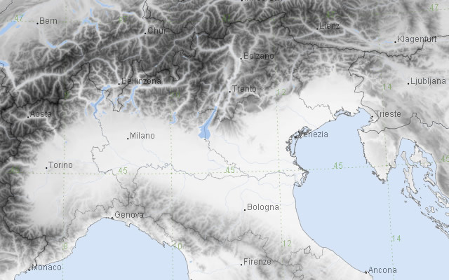
Example of a large zoom. Only those places marked “large” are plotted.
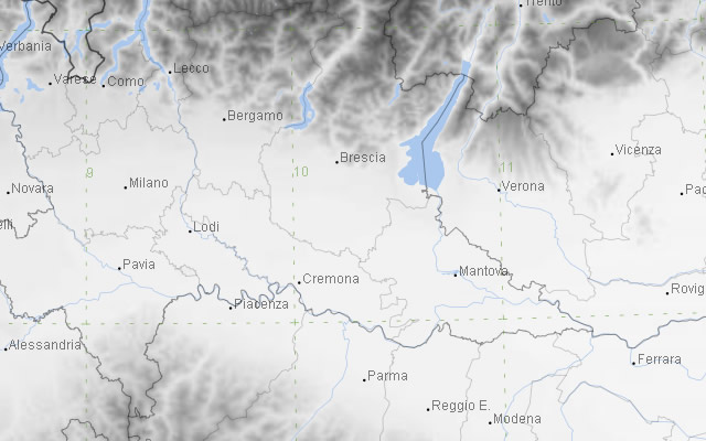
Example of a medium scaled zoom. Both places marked “large” and “medium” are plotted.
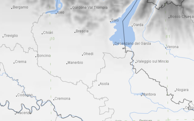
Example of a detailed zoom. All places “large”, “medium” and “detail” are plotted.
- "Geographical Area", where it should be expressed in which of the MIDOP available geographical layers (here a list) the place should appear. For example if you want to show “Paris” both in UK and France maps, you must insert “Paris” twice in this table, one will be used while generating maps for the UK area, and the another will be used while generating maps for the France area.
